
NOAA’s latest update puts the odds of this El Niño becoming the strongest on record at 83% by the end of the year, and every snow forecaster with a newsletter is about to tell you what that means for your winter. The short answer depends on where you ride, and even more on something nobody can forecast in October.
This is the longer answer. Here’s what the update actually says, how El Niño moves storms around, where it has historically helped and hurt, and why the last very strong event is a useful reality check before you book anything.
What NOAA’s October 2026 update says
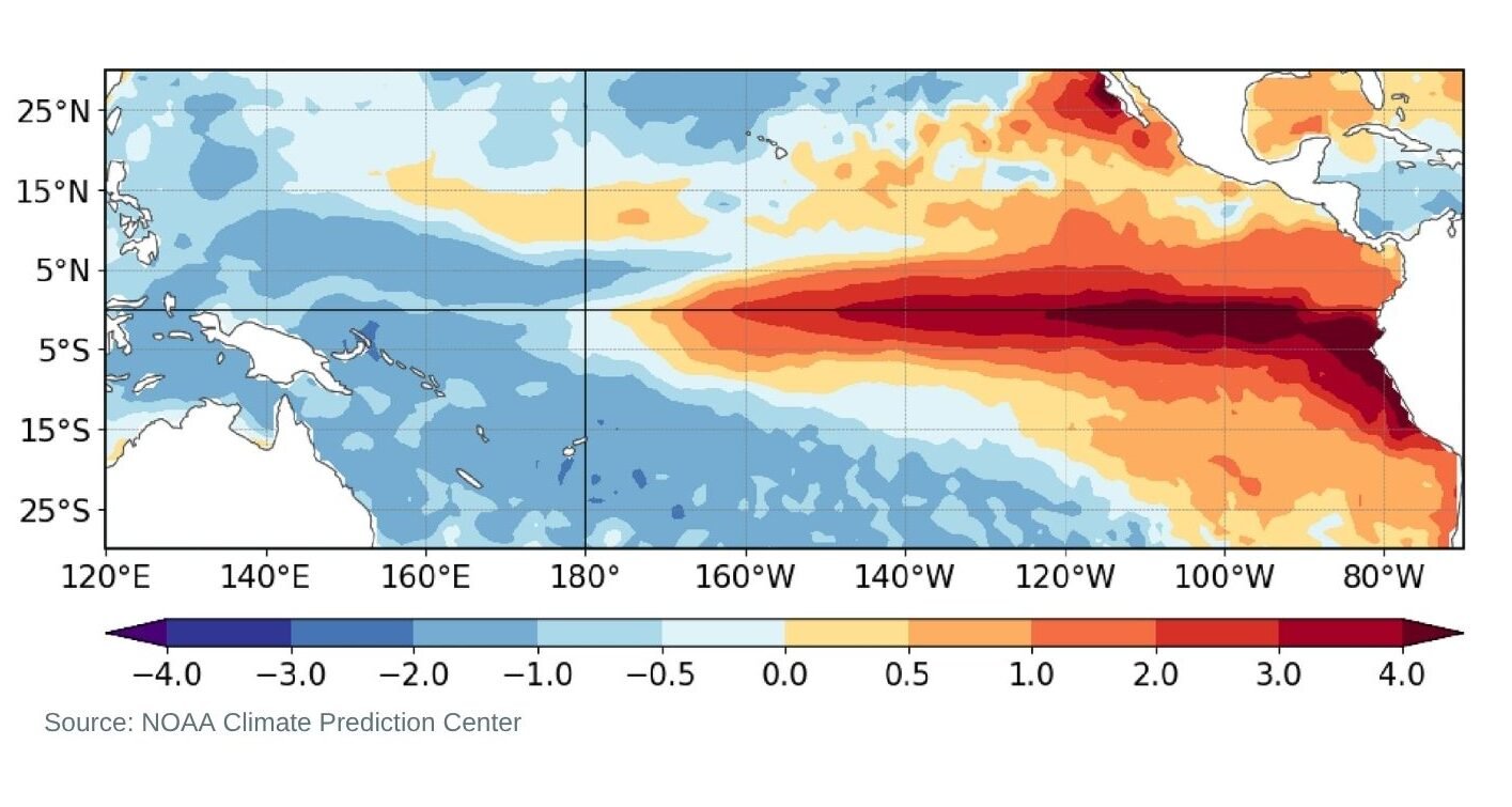
NOAA’s Climate Prediction Center published its monthly update on 8 October, and the event is still strengthening. The key Niño-3.4 index reached +2.1°C, and parts of the eastern equatorial Pacific ran more than 4°C above normal.
The forecast is for a strong to very strong El Niño through January to March 2027, with odds above 83%. The next update is due on 12 November.
How likely is a record El Niño?
Record has a specific meaning here. NOAA counts it as a three-month reading of +2.5°C or more on its Relative Oceanic Niño Index, which would make this stronger than any El Niño since 1950.
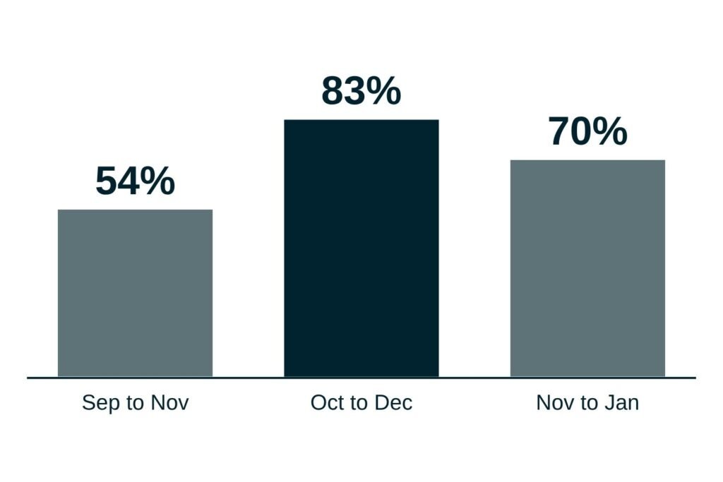
The odds of hitting that mark are 54% for September to November, 83% for October to December and 70% for November to January. They’ve been climbing all year. In June NOAA gave a 63% chance of a very strong event, by July that had risen to 81%, and in August it put the odds of a record-breaking event at 69%. September’s update lifted that to 75%, and October’s to 83%.
For context, AccuWeather ranks 1982-83 as the strongest El Niño on record, with 2015-16 in second.
How El Niño changes the storm track
El Niño starts as warm water in the tropical Pacific, but skiers feel it through the jet stream. In a typical El Niño winter, the polar jet stays further north, while the Pacific jet runs across the southern US.
That reshuffles where storms go. NOAA is careful to say the effect on US winters is about probability rather than certainty, though stronger events tend to tilt the odds harder toward the expected pattern.
Where El Niño usually helps and hurts in North America
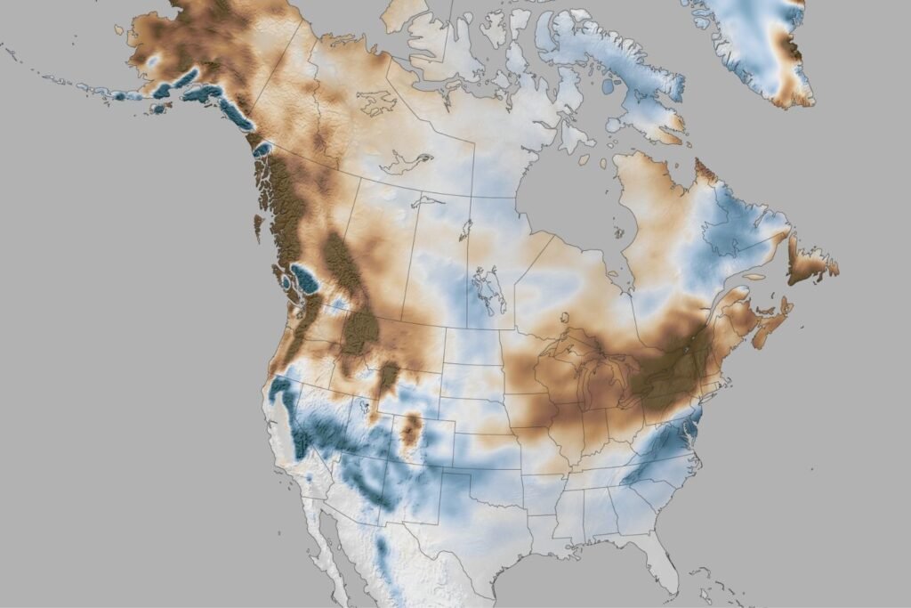
Historically, the wet signal is strongest across the southern US, with southern California the most likely to benefit and northern California less so. Southern Colorado and the San Juans also tend to do well when the southern storm track gets going. This season’s early forecasts follow that script, with OpenSnow favoring above-normal snowfall across California and Nevada, and January to March looking like the strongest stretch.
The north is the other side of the ledger. Western Canada through the northern and central US usually runs warmer than normal, and snowpack in the northern Rockies can come in lighter. OpenSnow expects below-average snowfall across much of British Columbia this winter, pointing to warmer temperatures and a more southerly storm track.
None of this writes off a season. One well-timed storm cycle can carry a mountain, and the northern ranges will still have their good weeks.
Already booked for Canada? Our Whistler guide and Banff guide cover how to make the most of the trip, whatever the snow does.
What about Japan and the Alps?
In Japan, El Niño works through the winter monsoon that pushes cold air across the Sea of Japan. When that monsoon weakens, Honshu tends to see less snow, while Hokkaido is much less affected. Ski Asia’s analysis of decades of Niseko data found some of its best seasons happened during El Niño winters.
The Alps are still harder to read. Forecasters there find no statistically robust link between El Niño and Alpine snow, and even the strongest past events have played out differently from one winter to the next.
Why wetter doesn’t always mean snowier
This is the part the headlines skip. El Niño winters often run warm, and the storms that come in on the southern track can carry subtropical air along with the moisture. Whether that lands as powder or rain comes down to the temperature on the day, and that’s not something anyone can call this far out.
2015-16 is the obvious cautionary tale. That very strong El Niño fostered the warmest winter on record across the mainland US, according to NOAA. Tahoe, which sits in the unpredictable zone between the northern and southern storm tracks, finished with only near-average snow around the lake.
What it means for your trip
We’d treat El Niño as a nudge, not a verdict. The southern US and southern Rockies have history on their side, the north leans warmer, and Japan and the Alps follow their own rules.
In a warm, wet winter, snow levels and elevation decide whether a storm brings powder up top or rain at the base, so if you’re booking now, flexible dates and higher terrain are worth prioritising. Otherwise, wait for NOAA’s November update and the seasonal outlooks that follow before locking anything in.
We’ll keep tracking it as the event peaks. If you want the next update without refreshing NOAA’s website, our newsletter is the easiest way to get it.